Monday, September 23, 2024

Nick and Delany's wedding

 September 23 2024

On the morning of September 19th, we harnessed the Silver Bullet to our home on wheels and headed north for my granddaughter’s wedding on Kent Island Maryland. The driving distance is 525+/- on our preferred route up the coast, mostly on Highway 17.


KOA at Cape Charles Virginia


We have divided the trip into two parts, the first day we will drive 345 miles to a KOA campground on the eastern shore of Virginia near Cape Charles. The next day, Friday the 20th, we will go 180 miles north thru Virginia and Maryland and lower Delaware. Then west back into Maryland and to our destination, Tuckahoe State Park. 


our campsite at Tuckahoe State Park

Tuckahoe will place us about 20 miles from the wedding venue on Kent Island. Matapeake, the site for the wedding, is a county park located on the shore of the Chesapeake Bay. It is available to rent for social occasions.


The weather on Saturday the 21st of September was nearly perfect for the outdoor wedding. There was an indoor welcome center with bar and hors d’oeuvres but the wedding was outdoors and the reception immediately afterwards was in a large tent.


The wedding was just as perfect as the weather, the bride was beautiful, the groom handsome and everything went off without a hitch. They had many friends, family and business associates as guests, and everyone seemed to be enjoying the occasion. In fact, I said afterwards, I don’t think I have ever been to a wedding where everyone had such a great time. 


We spent another night at the campground at Tuckahoe State Park and backtracked the same route we took north. We spent one night at Oceans RV Resort at Holly Ridge, North Carolina before resuming our journey on Monday, arriving home early in the afternoon.


It was a pleasant drive, both up and back, the only thing notable was the Wilmington North Carolina area had received 30 inches of rain the night before we passed through. About 20 miles south of the city the northbound lanes of highway 17 had been completely washed out and the road was closed to traffic. We had to detour on some local back roads. We decided to stay on the inland roads until we were well north of Wilmington and the flooded areas. 


Sunday, September 15, 2024

PART ELEVEN-Martinsville and then homeward bound.

 Part ten August 21 2024

Martinsville

The rest of the trip was uneventful, we parked in one of the six transient pull-thru sites at Indian Heritage in Martinsville. After setting up the RV we drove to nearby Axton to check on the family cemetery. As far as we know no one in the family has been out there for a while. In addition, we have a new people cutting the grass. They live right across the street, but we had never met them. Millie has been in contact with the Kathy and she wanted to meet her. Millie had texted her and she and her future husband came over when they saw us pull up in the truck. 

Bray family cemetery


The landscaping as far as the grass cutting and trimming goes is in good shape. Millie is planning a workday in the fall to cut back some of the overhanging branches from trees on the property line. 

As I mentioned earlier in the blog, we would not be visiting either of Millies sisters this trip because of Covid outbreaks. So, we have an extra day here in Martinsville. We thought of going home a day early, but the site is paid for and we weren’t going to get a refund if we left. Besides, our schedule is always flexible, so we decided to have a fun day. We drove to Millie’s home place to see if the new owners had done anything to the house. 

The Walmart of farm supplies.


We went to Rural King, the Walmart for all things farming. We went to Belk’s, Goodwill, dollar Tree and the gas station. We went to Jerry’s for a giant-sized pizza, we ate it for three days! We laid around the RV, I wrote in the blog, Millie took a nap while playing puzzles on her iPad and slept so deeply I had to keep checking to make sure she was breathing! It was a good day.

We ate leftovers for two days!


We took a new route south around Greensboro; it was a few miles longer but completely avoided the freeway mayhem through Greensboro. From Asheboro on down we ran the same route we always take, we arrived back at the storage lot early in the afternoon, parked the trailer and were soon on our way home.

Dark blue route home


PART TEN-The road to Martinsville

 Wednesday August 21 2024

We left Damascus and drove to Martinsville this morning. We traveled a different route on this trip. Instead of taking Hwy 58 all the way across the bottom of Virginia we drove northwest to Abingdon and got on interstate 81 heading north. We drove the interstate up to Fort Chiswell a distance of 60 miles, then took I-77 south to reunite with 58. This long yet faster route eliminated the very windy section of 58. 

Dark blue is our route


On 58 we traveled east stopping for a short break the Poor Farmers Market in Meadows of Dan. It’s an old country store that’s been there forever. We bought some fresh tomatoes and peaches before continuing our trip. 

Felicia Shelor, owner of the market


On this next leg we were looking forward to see the progress of the new road being built at Lovers leap, a spot known for the obvious legend as well as the treacherous mountain crossing. 

Moving a mountain


They have shaved a good deal of mountain top and filled in some valley but they still have a long way to go, they haven’t even started any of the bridges needed to fill in the gaps. We will remember this passage for a different reason, as we came off a very steep grade we had to stop for a one lane section. There were 3 vehicles already stopped by the flagman, I think they were all construction trucks.

Carving out 7 1/2 miles of mountain to widen and straighten the road.


We were maybe four lengths behind and approaching the last vehicle at maybe 20 mph when the brakes just faded away. I quickly engaged the emergency park brake, and our rig slowed but I could see we would not stop in time. The escort truck had not arrived yet with the oncoming traffic so I veered into that lane, as we passed the stopped vehicles I realized I was going to stop soon so I went further left onto a shoulder so as not to impede the oncoming traffic. 

Brake fade is a real concern when you are traveling with a heavy load on long steep declines. The ironic thing is in all our tens of thousands of mile towing we had never experienced anything like that. I have automatic trailer brakes, and I could have locked then up with the manual control if I had thought of it. It all happened really fast. 

As soon as you stop and quit generating heat in the braking system the braking force returns so by the time the road cleared we continued on  down the mountain. We continued in 1st gear using the engine/transmission braking to keep our speed very low. 

I am going to do a couple things to the system to hopefully never have that happen again. In addition, I need to discipline myself to never take declines for granted. I could have used more transmission braking as well as increasing the force of the trailer brakes. I have a note on the dash now reminding me of our overall height. I guess I need another one with downhill procedures!

Update: I am certain the cause of our brake fade was due to the deterioration of the brake pads. I have since seen pictures of others with the same problem with the pads. We have replaced them with a brake pad made for heavy hauling and trailer towing. 

close up of brake pad


PART NINE-Conclusion

 Part nine-conclusion

Biking the Damascus to Abingdon section of the Virginia Creeper is something I have wanted to do for some time and I’m very pleased that I finally made the time to bike it. The trail is not a great adventure, but it was a fun challenge for me. I was somewhat concerned about my worn-out knee joint, but it never gave me any problem, during or after the ride. 

I wasn't wearing these to keep my knees warm!


There are sections of the trail with no cell service, but Millie was able to track me the entire distance. I guess the phone’s GPS was bouncing off satellites during those cell outages or it just used dead reckoning to plot my progress. 


Millie said at times I would go seven and eight miles an hour, but I wasn’t trying to race across. I pedaled at what I thought was a leisurely rate and just enjoyed the journey. I got on the trail at about 9:45 and arrived in Damascus at 1:30.

I had no mechanical problems with the bike until I got to the highway 58 bridge. I had used 4th gear for the entire run until this last little bit when I shifted down to 3rd because of a slight uphill section. While in 3rd gear if I pedaled backwards the chain would come off the sprocket. The derailer must need some adjustment. 

Would I do it again, yes indeed. In fact, I’m already thinking of doing the whole 34 miles in one day. Starting at White Top on a rental mountain bike from one of the shuttle services. I think wider tires are prudent for the downhill portion. I would then switch to my bike and do the second 17 miles to Abingdon. 

34 miles on gravel, sounds like fun to me!


PART EIGHT- On the trail

 Part Eight-On the trail from Abingdon to Damascus

August 21 2024

I’ll never be a creative writer, so don’t expect essay in the caliber of the naturalist Henry David Thoreau but Ill do my best to tell you what I saw along the trail and try to make it interesting. 

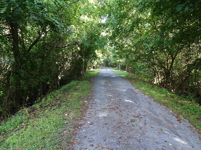
Typical trail on the Abingdon end


The several miles are under a living canopy, almost a tunnel thru the avenue of trees. Being an old railroad bed the trail is flat and straight. The base is crushed cinders for most of the journey, with occasional dirt paths or wooden decking on the 20 bridges I would cross.

First of many bridges.


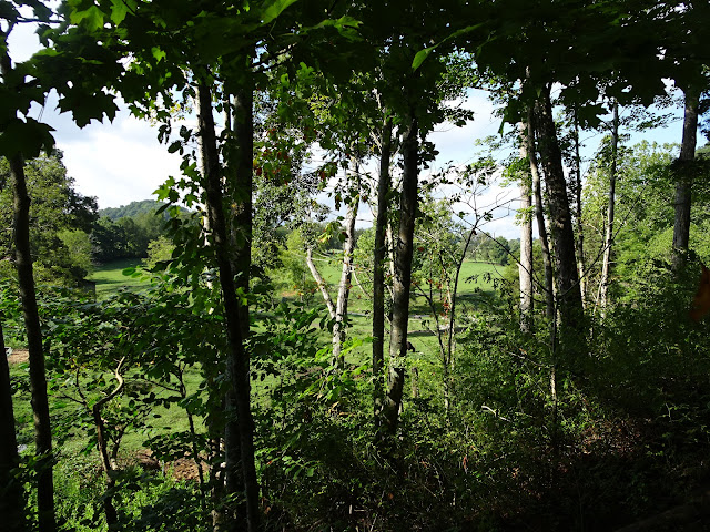
Every so often I would get a glimpse of the countryside through openings in the thicket of vegetation on the sides of the trail. The country is rolling hills, sometimes with fences and pasture for cows, sometimes beautiful fields of grass usually leading your eye to an expensive home on the slope of the hills. At about one and a half miles there is a road crossing the trail, on both sides there are estate sized lots and impressive homes. This is a golf course community so there is all that greenery intermingled with the homes of wealthy Virginians.


About three miles down the old road bed the terrain opens up and passes through working farm property There are several gates across the trail but most were left open, the exception being the passage through a farm yard where you had to open and close two gates to keep the livestock where they are supposed to be. There were several country road crossings in this area, one had a small parking lot for folks accessing the trail here.


It was in this farm country where I crossed several large bridges that kept the track level as it traversed the valleys in the fields. The Middle fork of the Holston River made its appearance in this area and it would be an almost constant companion as the trail followed along side it.

Holston River


The largest bridge crossing is right at the junction of the Middle Fork and the South Fork of the Holston. From this junction it passes under the bridge and becomes a navigable waterway. It meanders south into Tennessee where it becomes the South Holston Lake.


Now following the South Fork of the river the trail soon passes Alvarado station, an old railroad stop from the trains bygone era. It is now a rest stop along the river with rest rooms and a few private homes.


After Alvarado there are many sections where the railroad bed was carved from the rock that lined the riverbank. It continues to follow the river, sometimes in forest and sometimes open ground, but never as pretty as the beginning of the trail back in Abingdon. 


When you see the route 58 bridges looming overhead you know the party’s about over. The trail runs for another couple miles, the river on one side and highway 58 on the other. The environment becomes more urban with homes on the river and businesses on the highway. 

Highway 58

Damascus the center of the trail


You know you are on the outskirts of Damascus, but when you see the red caboose in the park, you know you have reached the halfway point of the trail. Only the strongest of athletes will be biking much further in this direction. From Damascus the trail climbs 1600 feet in seventeen miles terminating at the summit of White top mountain, the second highest point in Virginia (3500 feet). 


I would continue pedaling for some portion of a mile crossing two more bridges before leaving the creeper and going down a side street in town to the Damascus Creek RV Park.

Our spot at Damascus Creekside RV Park


PART SEVEN-The Abingdon end of the trail.

 Part seven – Abingdon to Damascus

August 20 2024

Millie delivered me and the bike to the beginning of the Virginia Creeper trail in Abingdon Virginia this morning. The trail is a 34-mile multi-use path that follows an old railroad bed through scenic farmland and mountains. The most popular section is the 17 mile downhill run from the top of Whitetop mountain to the town of Damascus. Being conveniently close to Millie’s sister’s homestead we have biked down the mountain six times. It is a thrill I recommend to anyone young or old. 

I peeled off the layers as the day warmed up.


Today I would be biking the relatively flat section from the opposite end, beginning in Abington and biking seventeen miles to Damascus. As with almost any subject nowdays,  Youtube gives you a primer on what to expect, and that’s good for preparation but you won’t know the trail till you ride it!

First some facts.

I hadn’t expected all the other people using the trail on this end, but it does start in downtown Abingdon. In the beginning there was a variety of trail users and more of them than I expected.   I don’t mean it was crowded but you were usually in sight of someone for the first couple miles. The further along you went the fewer companions you had.


There were walkers, singly and in small groups. Most of these were not thru hikers, they were just going out some distance and returning to the entrance. Yes you can take your leased dog on the trail and there were a number of them, all of them walked by singular women hikers. I wonder if they were just stuck with the family dog duty or were the dogs security?  At about the two mile marker all the walkers had turned and were returning to Abingdon.


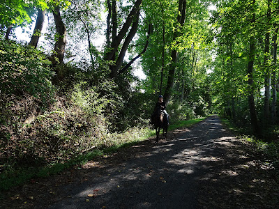
Bikers all tended to be all transiting the trail to Damascus. About two thirds of them were in pairs with about half man/women pairs and the rest men/men. All the single bikers were men. I also encountered one runner who was 91 years old and one women on a horse.

Horse


I think all the mixed pair bikers were on E-bikes. I just don’t understand this. E-bikers don’t pedal much, if at all, so there’re not getting any exercise. They also go way too fast to see much of their surroundings, why are they even bothering to do it? 

Next post will be my experience on the trail


Part Six- Rain Delay

 Part six rain delay

Monday August 19 2024

Looking at the local weather here in Damascus, Today will be a rainy day, tomorrow will be clear but cool. I’ll take the cool weather over the rain, so the bike ride is scheduled for Tuesday. 

Pic from Google street view, usually can't find a parking spot here.


Millie and I took a little ride in the country and happened to be in Chilhowie at lunchtime. It worked out well because there is a good Mexican restaurant there. We enjoyed an excellent meal at El Campestre and had the good sense to take half of it home, avoiding the overeating coma we had the other day in Marion. 


We meandered our way down to Abingdon and found the beginning of the Creeper Trail where Millie will drop me off tomorrow morning. We browsed the local Goodwill and a Dollar store. I bought the DVD About Schmitt with Jack Nicolson and Cathy Bates. I thought it was a comedy, but it is a very sad story. If the little bit of humor in it classifies it as comedy, it is a very dark comedy.

Did they think seeing Cathy Bates naked could save this movie?


Part Five-Moving on to Damascus Virginia

 Part five

Sunday August 18, 2024

When we rolled out of bed this morning at 7:30ish, some folks had already left the Rally grounds. We took our time and by 9:30 when we departed about half of our neighbors had vacated their RV sites. I was happy to note that even though hundreds of RV’s probably dumped their holding tanks this morning the sewer system here handled it all without so much as a burb. We were parked about in the middle of this huge flat field and I don’t know which direction all the affluent was headed, but its all gone somewhere.

Dark blue line is our route


Our route this morning would take us on country roads up through Linville Falls, Grandfather Mountain and Boone. It sure is pretty country up here, it’s a shame it gets cold in the winter, I'd sure like to live in a place like this, but I don't do cold. 

No more cold for me!


Our trip to Damascus was only about 90 miles and we traveled through North Carolina, then a little bit of Tennessee and finally Virginia. Damascus Creekside RV Park is right in the town of Damascus. It is a small park consisting of around nine or ten sites, all of them backing to Laurel Creek. Cindi, the owner, spends half a year at the campground and the rest of the time at her property in Florida. It must be nice!


Either Monday or Tuesday, I will ride my bike on the Creeper trail from here to Abingdon, a distance of 17 miles. It’s overcast and we had a bit of rain here today, so I’ll see which of the next two days looks better. The trail is gravel with several wooden bridges across low areas, creeks and rivers. It crosses the Holsten River at about the halfway point which is the lowest elevation. No matter which direction you start from, your first eight miles are a gradual drop in elevation and then the ground rises about the same height on the second half. The drop in altitude over the eight miles is about 1000 feet, it should not be too hard to pedal the upside.

The part I would do is on the left from Abingdon to Damascus


Back in part one I explained how we rescheduled the trip because of the hurricane. That worked out well for us, but now we are shuffling the deck once again. The first stop we moved from the front to the tail end of the trip was Damascus. Here I would do the bike ride and Millie’s sister lives near here. The next stop is Martinsville where we planned on checking on the family cemetery and then stopping in Greensboro to visit Millie’s other sister.


While we were still in Marion North Carolina Betty called to tell us that she and her son had come down with Covid. She probably contracted it while visiting her husband who is in a nursing home. Anyhow, we will not be visiting them on this trip.


The second stop in Martinsville will still happen, I doubt anyone in the graveyard has Covid. However, Millie’s sister Lucille who lives in a nursing home called to tell us we probably would not want to visit her on this trip. She is ok, but many other residents have come down with Covid. She is staying in her room with the door closed, we hope she can dodge the bullet and not catch the virus. We will not be stopping to see her on this trip.


Final thoughts on 2024

  Dispatch from the Road-2024 Final thoughts Looking back over the year I am reminded of all the adventures we’ve had and all the enjoym...